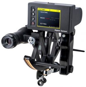
Digital Sextant
The Digital Sextant is the first electronic sextant in the world and gives you quick and rapid identification of your location plus reliable back-up in case of GPS malfunction or failure.
A sextant is an essential instrument on any ship or vessel, designed to measure the altitude angle between the horizon and celestial body (such as the sun, moon or a star), and is used to determine the ship’s latitude and longitude position, especially in the event of the failure of the ship’s GPS navigation system.
 The advantages of the Digital Sextant instrument, certified by CE and FCC, include:
- Standalone device. No external systems or sources required for calculations
- Fixes the position of the ship quickly (within 1 second after sighting)
- Easy to operate (no training required) whether stationary or moving
- Minimises the attendant risk of operator errors
- Each reading is stored and can be printed via a computer connection
Powered by internal rechargeable batteries, the Digital Sextant has several modes, basing the location fix on two or three celestial bodies (sun / moon / stars / planets / etc). Alternatively, there is a simple mode that allows a rapid, lower accuracy position fix from a single observation of the bottom of the sun.
The modern Digital Sextant provides the ultimate guarantee, in the event of failure or ‘adjustment’ of the GPS system. Whilst it is electronic, it is stand-alone and not reliant on any other external sources or systems. Recognising the fragile nature of the GPS network, with the potential for hacking etc, the US Navy has recently returned to teaching and utilising celestial navigation.
For naval and similar applications, an EMP shielded protective case for the Digital Sextant is available as an optional extra. The product is covered by a twelve month worldwide warranty.
If you would like a sextant that provides accurate location identification and reassurance in the event of GPS failure and/or GNSS (Global Navigation Satellite System) issues, then please contact us to place an order or for further information, or you can download the manual here.